Cambridge Civic Journal Forum

December 4, 2016

City of Cambridge to Host Fire Recovery Resource Center; Buildings Sustain Serious Damage

Filed under: Cambridge — Tags: , , — Robert Winters @ 10:37 pm

Residents Displaced by December 3 Fire Encouraged to Register with Red Cross of Massachusetts

Berkshire St. fire, Dec 3, 2016
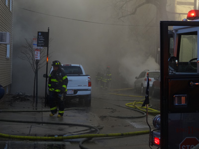
Dec 4, 2016 – Three buildings are being torn down in Cambridge and at least one other will be partially razed for safety reasons. The Dec 3, 2016 fire in the Harrington/Wellington/East Cambridge neighborhoods caused significant damage to six buildings, and fire or water damage to at least five others.

As of 3pm, 48 displaced families, representing 104 individuals, have registered with the Red Cross of Massachusetts. There may be more families and individuals that have not yet registered and the City is strongly encouraging all displaced individuals to register with the Red Cross by calling 800-564-1234 or by coming to the City’s Fire Recovery Resource Center at City Hall.

The first step in receiving assistance from the City is to contact and register with the Red Cross of Massachusetts.

On Mon, Dec 5, from 8:30am-8:00pm and Tues, Dec 6, 8:30am-5:00pm, the City is hosting a Fire Recovery Resource Center on the 2nd floor of Cambridge City Hall, 795 Mass. Ave. Impacted residents can meet with representatives from the City of Cambridge, American Red Cross, Commonwealth of Massachusetts Emergency Management Agency, Commonwealth of Massachusetts, Division of insurance, Commonwealth of Massachusetts, Division of Transitional Assistance, Housing and Development, Commonwealth of Massachusetts, Department of Public Health Commonwealth of Massachusetts, Department of Mental Health, National Organizational Voluntary Active Disaster, and Riverside Community Care.

The public can donate to the Mayor’s Fire Relief Fund online at www.cambridgema.gov/firefund or by sending a check to:

Mayor’s Fire Relief Fund
Cambridge City Hall
795 Massachusetts Avenue
Cambridge, MA 02139

While greatly appreciated, the City is urging people to hold off on donating food, clothing or material goods at this time. Should this change, an announcement will be made in the media and on the City’s website and social media outlets.

A number of street closures will remain in place in Cambridge. The following streets have no access for pedestrians or vehicles:

  • Berkshire Street – from York Street to Plymouth – indefinite
  • Plymouth Street – Cardinal Medeiros Ave to Berkshire Street – indefinite
  • Vandine Street – Cardinal Medeiros to Berkshire Street
  • York Street – Willow Street to Berkshire Street

Residents impacted by the fire can call the City’s dedicated phone line, 617-349-9484, with questions regarding the fire or recovery assistance.

City Encourages Families and Individuals to Register with the Red Cross of Massachusetts
Mayor’s Fire Relief Fund Accepting Online Donations

Dec 4, 2016 – The City of Cambridge is encouraging displaced families and individuals impacted by the December 3, 2016, fire in the Harrington/Wellington/East Cambridge neighborhoods to contact the Red Cross of Massachusetts to register for assistance.

“The most important first step displaced families and individuals can take is to register with the Red Cross of Massachusetts,” said Louis A. DePasquale, City Manager.

Individuals can register by calling the Red Cross at 800-564-1234 or by stopping by one on of the following drop-in sessions:

  • Sun, Dec 4, from noon – 6pm at the Frisoli Youth Center, 61 Willow Street;
  • Mon, Dec 5, from 8:30am until 8:00pm on the 2nd floor, Cambridge City Hall, 795 Mass. Ave.; or
  • Tues, Dec 6, from 8:30am to 5:00pm on the 2nd floor, Cambridge City Hall, 795 Mass. Ave.

The key first step that needs to occur for the City to assist and communicate with the impacted families and individuals is for them to register their information with the Red Cross.

Members of the public can donate to the Mayor’s Fire Relief Fund online at www.cambridgema.gov/firefund or by sending a check to:

Mayor’s Fire Relief Fund
Cambridge City Hall
795 Massachusetts Avenue
Cambridge, MA 02139

The City appreciates the numerous offers for volunteers and donations of physical assets; however, what is needed most is donations to the Mayor’s Fire Relief Fund. The City is currently not accepting physical donations.

Speed Limit on Cambridge’s City-Owned Streets Being Reduced to 25 MPH

Filed under: Cambridge,transportation — Tags: , , — Robert Winters @ 10:20 pm

25mph
City of Cambridge implements component of Vision Zero Initiative

Dec 2, 2016 – On Thurs, Dec 8, 2016, the speed limit on City-owned streets in the City of Cambridge will be reduced to 25 Miles Per Hour (MPH), unless otherwise posted. This is an important step towards improving the safety of everyone who lives, works and visits Cambridge, and is a significant component of the City’s Vision Zero Initiative.

Speed is one of the most important factors in traffic safety; crashes that occur at lower speeds cause less injury. In fact, a pedestrian hit by a car traveling 40 MPH has a 1 in 10 chance of surviving a crash, while a pedestrian hit by a car traveling 20 MPH has a 9 in 10 chance of surviving. “By lowering the speed limit in Cambridge, we are prioritizing safety and making our City more walkable, bikeable and livable,” said City Manager Louis A. DePasquale.

“We know that lowering car speeds is one of the most important ways to protect our most vulnerable users and work together to achieve our Vision Zero goals,” said Joseph Barr, Director of Traffic, Parking, and Transportation. “I encourage everyone who travels in Cambridge to take their time as they move through the city; by staying under 25 MPH you’ll be keeping all of our citizens safer and be able to better enjoy our beautiful city.”

The Cambridge City Council approved the new lower speed limit reduction on November 7th, by accepting Sections 193 and 194 of the Municipal Modernization Act. These sections grant municipalities the right to lower speed limits in thickly settled areas and to create 20 MPH safety zones. The City will be posting the new speed limit at the City line at various locations, as permitted by State law.

With this change, Cambridge will be joining neighbors like Boston, Somerville, and Arlington that are making the whole region safer by creating a 25 MPH zone within the inner core.

For additional information contact Brooke McKenna, Assistant Director for Street Management, at bmckenna@cambridgema.gov or 617-349-4723, or visit www.cambridgema.gov/visionzero.

December 2, 2016

Where did the Amanda Phillips crash happen? And why?

Filed under: Cambridge,cycling,Deaths — Tags: , , , , , — jsallen @ 10:47 am

In a previous post, I stated that Amanda Phillips’s fatal crash occurred outside Inman Square, not in the Square.

An examination of news photos and a Google Street View establishes the precise location — 1423 Cambridge Street, just west of the Square.

The Google Street View

Boston Globe article with photo: note the blue recycling bin peeking out from behind the trash barrel, the distinctive leaning tree, and the ambulance parked on Hampshire Street in the background.

The Cambridge Patch has an even better photo.

This evidence establishes that Phillips had exited Inman Square. It has been reported that she rode off the sidewalk. That would place her in the same precarious situation as with the bike lanes exiting the Square in a “Peanut Roundabout” proposal advanced by the Boston Cyclists Union.

I also commend readers to Paul Schimek’s examination of factors which led to the crash.

December 1, 2016

A Peanut in Inman Square?

Inman Square is a difficult, pre-automotive, cramped, often congested, diagonal intersection. Thoroughgoing safety and traffic-flow improvements are not possible, short of tearing down buildings to create more travel space, or an expensive grade separation.

Anne Lusk, Visiting Fellow at the Harvard School of Public Health and a relentless advocate for on-street barrier-separated bikeways, has promoted a proposal for a “peanut roundabout” as a solution to the problems with Inman Square.

A grade separation was built long ago, farther west where Cambridge street runs between Harvard buildings. Though Lusk works at Harvard University, Inman Square does not adjoin the campus, and the political and financial resources of the University evidently don’t come to bear on the Square’s problems.

A Web page from the Boston Cyclists Union describes the “peanut roundabout” concept which Lusk is promoting for Inman Square. Here’s a conceptual drawing from the Web page:

"Peanut Roundabout" concept for Inman Square

“Peanut Roundabout” concept for Inman Square

I do think that the peanut roundabout concept is clever in itself. By eliminating traffic signals, this design might improve traffic flow.

— except for problems for bicyclists and pedestrians.

In the conceptual drawing on the page, to continue across the square in the same direction, bicyclists are directed to follow a circuitous route on separated bikeways, subject to right-hook risks, and turn sharply left after waiting at locations where they would block other bicyclists bearing right. There is no waiting area other than the narrow bikeway in which the bicyclists approach. The page describes the crossings as “European-style protected crossings” — but they aren’t. Strictly speaking, in traffic engineering, “protected” means that conflicting movements are prevented by traffic signals. No traffic signals are shown in the conceptual drawing. Four of the six crosswalks are raised, and these would slow motorists, but there are no waiting areas that would make it clear whether bicyclists will be turning across motor traffic or proceeding straight.

All in all, I cannot imagine how this concept would work for bicyclists or pedestrians without traffic signals for the crosswalks. Signals, though, would result in more motorists in the roundabout blocking other motorists’ travel in the roundabout. The conceptual drawing avoids raising this issue. Few vehicles are shown in the roundabout, inconsistent with the many in the connecting streets.

The conceptual drawing shows door-zone bike lanes leading to and from Inman Square at every approach. Earlier this year, cyclist Amanda Phillips was killed when the opening door of a parked vehicle flung her under a truck — the incident which led to calls for redesign of the Square. She was, however, not in the Square: she was had left the Square. (Identification of the crash location) It has been reported that she was exiting the sidewalk just before she was doored — so, she came from behind the vehicle whose door opened in front of her. What lessons from this crash have informed the proposed peanut design? Apparently none. The bike lanes shown at exits from the Square place bicyclists in the same hazardous situation as Phillips: emerging from behind parked vehicles, rather than where they might be visible with a driver’s-side mirror or a glance over the shoulder.

The page claims that “[s]uch a design could radically improve traffic flows, safety, and the community fabric of crash-prone Inman Square.” It would be useful in evaluating proposals, and claims like these, to have  a traffic capacity and flow analysis, and a crash study.  Instead, on the Web page, there is a list of claimed advantages, with no mention of potential problems and no analysis.

My overall impression of this design as a bicyclist, in addition to the concerns about safety, is that while it might increase appeal to bicyclists who are fearful of riding in mixed traffic, delays will be such that bicyclists who want to get where they are going will ride in the motor traffic. And let’s hope that they understand that safety would require them to ride in line with the motor traffic rather than keeping out of its way, as the designated routes strongly imply to be the key to safety.

The City of Cambridge has put forward two other proposals. A  “bend Cambridge Street” proposal is shown in the image below. Traffic on Hampshire Street would travel straight through, and traffic on Cambridge Street would zigzag. A similar “bend Hampshire Street” proposal is more or less a mirror image of this one. These proposals are similar to what has been done with Union Square in Somerville and at Lafayette Square (the intersection of Main Street and Massachusetts Avenue) in Cambridge.

City of Cambridge "bend Cambridge Street" proposal

City of Cambridge “bend Cambridge Street” proposal

The “bend” proposals include traffic signals and require bicyclists and motorists to make left turns. I do think, however, that the blue space in the “bend Cambridge Street” proposal might include bikeways, so  bicyclists on Cambridge Street could continue straight where the street bends left toward the first traffic light and then re-enter Cambridge Street by crossing Hampshire Street at the second traffic light rather than by turning left. (This would not be practical with the “bend Hampshire Street” proposal, because bicyclists would have to turn left across Hampshire Street to enter the blue space). The drawing below shows my proposal. Bicyclists would follow the red arrows.

Bend Cambridge Street proposal with shortcut bikeways

Bend Cambridge Street proposal with shortcut bikeways

The blue areas also might include useful social space — unlike the peanut roundabout proposal, where the extra space would be in the middle of the street.  The two traffic lights in the Bend Cambridge Street proposal would, to be sure, increase delay for motorists. Bicyclists following the red-arrow route would encounter only one traffic light.

I’ll admit that I don’t have any more thoroughgoing answers to Inman Square’s problems other than the two I’ve already mentioned — tearing down buildings or creating a grade separation — which are not going to happen. I’ll be trying to think of other possibilities, and please, you do also.

« Newer Posts

Powered by WordPress